


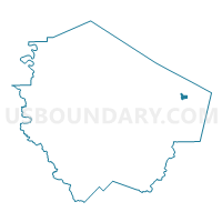
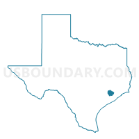
Voting District 2136, Fort Bend County, Texas
About
Outline

Summary
| Unique Area Identifier | 673194 |
| Name | Voting District 2136 |
| County | Fort Bend County |
| State | Texas |
| Area (square miles) | 0.78 |
| Land Area (square miles) | 0.77 |
| Water Area (square miles) | 0.01 |
| % of Land Area | 98.89 |
| % of Water Area | 1.11 |
| Latitude of the Internal Point | 29.56751350 |
| Longtitude of the Internal Point | -95.51620210 |
Maps

Graphs
Select a template below for downloading or customizing gragh for Voting District 2136, Fort Bend County, Texas


Neighbors
Neighoring Voting District (by Name) Neighboring Voting District on the Map
- Voting District 1134, Fort Bend County, TX
- Voting District 2033, Fort Bend County, TX
- Voting District 2034, Fort Bend County, TX
- Voting District 2036, Fort Bend County, TX
- Voting District 2089, Fort Bend County, TX
- Voting District 2108, Fort Bend County, TX
- Voting District 2115, Fort Bend County, TX
- Voting District 4062, Fort Bend County, TX
Top 10 Neighboring County Subdivision (by Population) Neighboring County Subdivision on the Map
Top 10 Neighboring Place (by Population) Neighboring Place on the Map
Top 10 Neighboring Unified School District (by Population) Neighboring Unified School District on the Map
Top 10 Neighboring State Legislative District Lower Chamber (by Population) Neighboring State Legislative District Lower Chamber on the Map
Top 10 Neighboring State Legislative District Upper Chamber (by Population) Neighboring State Legislative District Upper Chamber on the Map
Top 10 Neighboring 111th Congressional District (by Population) Neighboring 111th Congressional District on the Map
Top 10 Neighboring Census Tract (by Population) Neighboring Census Tract on the Map
- Census Tract 6709.01, Fort Bend County, TX (10,214)
- Census Tract 6710.02, Fort Bend County, TX (6,459)
- Census Tract 6709.02, Fort Bend County, TX (5,020)
- Census Tract 6707, Fort Bend County, TX (3,382)